Was lucky enough to take a little work break the last two months to spend travelling in Central America. In between the surfing, hiking the rainforests and lazing on the beach, did also get to see some pretty awesome volcanoes in Panama, Costa Rica and Nicaragua. Volcanoes are fascinating to me, not only because of the geology, but also how they provide many opportunities to the people living near them. All of the volcanos sit in active subduction zones
So, not remotely an expert on either the geology of volcanoes or volcanoes as hazards, but thought I’d profile three of the volcanoes here. Unfortunately, lots of the research is paywalled ☹ – so if anyone has resources do send my way! Open access references are at the end.
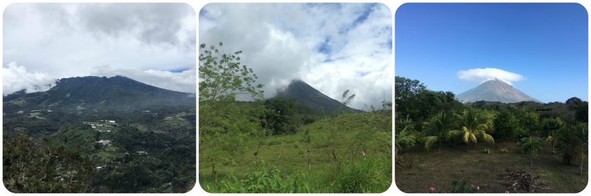
Volcán Barú, Panama
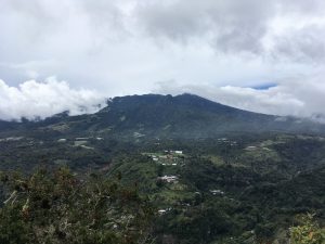
Volcán Barú near the town of Boquete in western Panama, is a potentially active stratovolcano whose last major activity was in the 16th Century. Previously volcanism was dominantly andesitic, although there are minor basaltic andesites, basalts and dacites in the region, all lying to the south of the summit, towards the Pacific Ocean. The summit, at 3474 m, is the highest peak in Panama and the volcano is surrounded by much lower lying populated valleys. More than 10,000 people live immediately adjacent to the volcano, which includes the tourist town of Boquete.
The eruptive history1,2 of the volcano is poorly studied, but appears to comprise:
- Pyroclastic flows – dominantly to the west of the summit where the town of Volcán is built on top of block and ash pyroclastic flows.
- Lava flows – Blocky, slow moving, viscous lava flows dominate towards the south, typically within 11 km from the summit.
- Debris avalanche deposits – Deposits lie to the west of the summit dome, extending 20 km towards the Pan-American Highway.
- Lahars – Form a plain to the south and southeast of the summit.
Scattered across the volcanic edifice are a number of small villages and many large-scale farms. The area around Boquete and the volcano produce many products including flowers, coffee, onions and peppers. A guide book in the hostel mentioned that 40% of all food products in the country are grown in the region.
From the volcano summit on a clear day you can spot both the Pacific and Caribbean oceans. Hiking to the summit for the sunrise, plus along numerous trails established within the National Park and on private land, are a big draw for tourists to the area. You can trek, go horse-riding, climb on the columnar basalts and soak in the waterfalls, amongst other activities, around the volcano.
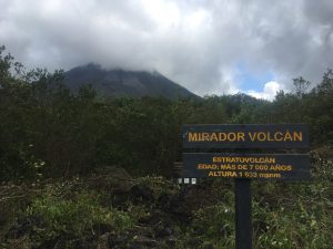
Volcán Arenal, Costa Rica
The eruptive history of Arenal4 is much better studied than Barú and there have been alternating periods of explosive eruptions and lava flows since the 1968 eruption:
- Lava flows – Basaltic andesite and andesite in composition. Have travelled beyond the base of the volcano extending towards Lake Arenal.
- Pyroclastic flows – formed from the vents on the upper western flank and collapsing fronts of the lava flows. Typically confined to the valleys on the volcano’s flanks.
- Explosive activity – both Vulcanian and Strombolian from the summit vents. In 1968, 3 new vents on the western side of the summit were formed. A crater also formed on the western side of the volcano in 1968 from which lava flowed until 1973 when a lava dome formed.
- Lahars – During the 1968 eruption, heavy rain generated lahars, which flowed down into the Tabacon River valley.
In 1968, pyroclastic flows caused the death of people in villages on the western flank of the volcano. Fumaroles on the flanks continue to emit gases, and the volcano is closely monitored. Within the Parque Nacional Volcán Arenal, there are restriction zones to prevent people approaching the summit.
Around the volcano, there is an incredible amount of tourist activity. The town of La Fortuna is one of the main tourist destinations in Costa Rica and tourists can book a myriad of activities from quad bike tours to canyoning to ziplining. Around the base of the volcano, there are numerous natural hot springs that have been utilised to make hot spring water parks and spas.
Volcán Concepción, Ometepe island, Nicaragua
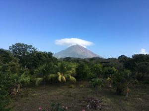
Volcán Concepción sits in Lake Nicaragua and is one of the country’s most active volcanoes. It forms an island in the lake with the neighbouring Volcán Maderas. Concepción is an active stratovolcano with frequent eruptions throughout the 20th and 21st centuries. The summit, at 1610 m, has a steep walled crater, 250 m deep. A number of cinder cones, lava domes and spatter cones lie around the summit. Due to frequent eruptions, the volcano has grown in height over the last 100 years, and the upper part remains unvegetated. Approximately 30,000 people live on Ometepe island, which has an economy based on tourism and farming.
There has been a range of volcanic activity over the last century5,6:
- Lava flows – Basaltic andesite and andesite lava flows in composition. Have travelled beyond the base of the volcano.
- Pyroclastic flows – from the vents on the upper western flank and collapsing fronts of the lava flows. Typically confined to the valleys on the volcano’s flanks.
- Tephra from the eruption plums is dominantly deposited to the west, thanks to the prevailing wind.
- Lahars – the volcano has often produced lahars that have impacted low lying areas around the island.
- Pyroclastic rocks – dominantly surrounding the summit crater. Poorly aggregated in places, leading to lahars after rainfall which has previously damaged homes and resulted in deaths around the volcano.
Volcano evacuation routes are in place across the island, and well signposted. As the island is essentially the volcano, heading up slope to avoid lahars can lead to more risk and the evacuation routes move people towards the ferry terminals. Numerous monitoring stations are in place (https://www.fdsn.org/networks/detail/NU/).
As with Barú and Arenal, the volcano is a draw for tourists. You can trek to the top of Concepción and neighbouring Maderas – both challenging treks. There is also a waterhole, fed by volcanic water, and numerous activities that can be booked. On the flanks of the volcano, there are farms, mainly for plantains and bananas, that are exported, as well as coffee and cacao crops.
The benefits of volcanoes
Something all three volcanoes have in common, as with other volcanoes around the world, is their opportunity for livelihoods. Whilst we often consider volcanoes to be an enormous risk, and yes, they can be, they are also a valuable resource for people. Volcanic soils often retain water well, and contain considerable nutrients, so the flanks of volcanoes can provide valuable land for farming (e.g. here). Hot springs can be fashioned into resorts and water parks, ideal for tourism. The volcanoes themselves are attractive for tourists wishing to see a volcano by hiking around them or climbing to the crater lakes. Tourism and agriculture in all three countries provide considerable employment opportunities.
Managing volcanoes
Given that volcanoes are important for livelihoods, care has to be taken when managing the risks they pose. As long as the volcanoes exist, people will make use of the benefits living close to them offers. After eruptions, people will often quickly return to their homes and land7, due to the need to protect their belongings and resume livelihood activities. In many parts of the world, volcanoes also have cultural significance (e.g. Ambae, Vanuatu). People have lived alongside volcanoes for decades and will judge for themselves whether they should return. One of the many challenges is that risks associated with volcanoes, such as lahars, is that risks are not visible. Just because the volcano doesn’t have an ash column, doesn’t mean it isn’t a risk. Rainfall can cause lahars after pyroclastic flows are deposited, and toxic gases may be present.
With all this in mind, the benefits of living near volcanoes have to be considered when communicating and managing their risks. In many cases, people do not have the luxury of moving away from active volcanoes and many will not want to. Volcanic eruptions can also be tricky to predict. People can be supported to best utilise the benefits of volcanoes, without further increasing their vulnerability. A combination of strong understandable science and community input with their own experiences should formulate local volcano management plans, with support for those who are living around active volcanoes when they may be displaced or lose their belongings8,9.
There are a lot of more qualified people who write about volcanic hazards, see some of the links in the references.
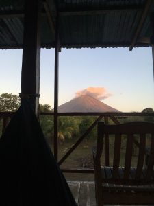
I leave you with my favourite of the 3 volcanoes – Volcán Concepción:
References
1. Sherrod DR, Vallance JW, Espinosa AT and Geehin JP. 2007. Volcán Barú – Eruptive history and volcano hazards assessment. United States Geological Survey: Open File Report 2007-1401. [Free]
2. Smithsonian Institution Global Volcanism Program. 2020. Barú. [Online]. Available at: https://volcano.si.edu/volcano.cfm?vn=346010
3. OVSICORI-UNA. 2020. Nivel de Actividad Volcánica. [Online]. Available online: http://www.ovsicori.una.ac.cr/index.php/vulcanologia/nivel-de-actividad-volcanica
4. Smithsonian Institution Global Volcanism Program. 2020. Arenal. [Online]. Available at: https://volcano.si.edu/volcano.cfm?vn=345033
5. Smithsonian Institution Global Volcanism Program. 2020. Concepciónl. [Online]. Available at: https://volcano.si.edu/volcano.cfm?vn=344120
6. Vallance JW, Schilling SP, Devoli G and Howell MM. 2001. Lahar Hazards at Concepción Volcano, Nicaragua. United States Geological Survey: Open File Report 2007-1401. [Free]
7. Barclay J et al. 2019. Livelihoods, wellbeing and the risk to life during volcanic eruptions. Fronters in Earth Science: Geohazards and Georisks, 14. [Free]
8. Wilmshurst J. 2017. “There’s no plastic in our volcano: a story about losing and finding a path to participatory volcanic risk management in Colombia” in Fearnley CJ et al. (eds) Observing the Volcano World. [Free]
9. Andreastuti S et al. 2019. Character of community response to volcanic crises at Sinabung and Kelud volcanoes. Journal of Volcanology and Geothermal Research, 382, 298-310. [PDF]